

Surveying Big Sandy
1772-1798
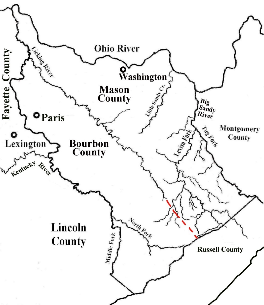
Very little has been written on the history of the Big Sandy Valley prior to the establishment of Floyd County in 1800. The first explorers and settlers in present-day Kentucky bypassed this mountainous region on their way to fertile land in the Bluegrass. Between 1738 and 1792, the year Kentucky became a state, the Big Sandy Valley was within the boundary of seven different Virginia counties: Augusta, Botetourt, Fincastle, Kentucky, Fayette, Bourbon and Mason.
On December 15, 1772, Lord Dunmore, Governor of the Virginia Colony, issued the “John Savage Grant” for 28,627 acres to sixty veterans of the French and Indian War (1756-1763). It extends from present-day Huntington, WV, down the Ohio, and up the Big Sandy to the mouth of Blaine Creek. Persimmon trees in the area marked ‘John Savage Sept 20th’ reveal the period when the land was being surveyed. Also on December 15, Dunmore issued grants for 2,084 and 1,525 acres to John Fry at and near present-day Louisa. A few trees in the grants were marked GsW, commonly used by George Washington’s surveying parties. The surveys from the mouth of Big Sandy to the main fork—10,890 acres it total—were the first ones recorded within the present-day boundary of Kentucky.
During 1772, Fincastle County was being formed out of Botetourt: approved February 1 and effective December 1.[1]
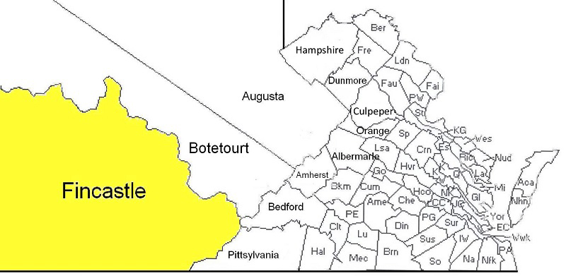
When Fincastle County Court first met in January 1773, William Preston was commissioned as County Sheriff and County Surveyor. Preston appointed six deputy surveyors, including John Floyd and William Russell. Floyd was also hired by Preston to teach school for his children at his plantation near present-day Blacksburg. During the next ten years, Preston and Floyd were closely associated surveying, protecting, and settling this westernmost region of Virginia.
In May 1773, Capt. Thomas Bullitt led a party of over thirty men down the Ohio from Pittsburgh as far as the Falls—present-day Louisville—and back east into the Bluegrass to make surveys based on military warrants for their service in the French and Indian War. Also during 1773, William Thompson led a party of sixty men into Fincastle County and surveyed thousands of acres of land in the lower Licking River Valley. In October 1773, Bullitt attempted to enter land claims from the surveys, but William Preston ruled them invalid since they had not been run by Fincastle surveyors. Thompson had the same problem with his claims.
In December 1773, Bullitt appealed to Lord Dunmore who overruled Preston’s decision and directed that Bullitt’s surveys be officially marked-off and entered in Fincastle records. He also issued grants for a few lots Bullitt had platted in present-day Louisville. Preston responded in April 1774 by sending John Floyd to lead three newly appointed deputies who had been with Bullitt the previous year. Thomas Hanson kept a journal of the expedition. By the end of the month, the surveying party was traveling down the Ohio from the mouth of the Kanawha River. On May 2, John Floyd made the first official Fincastle survey in present-day Kentucky for 400 acres across the Ohio from the mouth of Scioto River.
The deputies surveyed 16,400 acres during May on their journey down the Ohio to the Falls. At and near the Falls, an additional 41,000 acres were surveyed. Floyd ran two 1,000-acre surveys for himself. The surveyors split into two groups and ran surveys for 88,400 acres along creeks to present-day Harrodsburg, Frankfort, Georgetown, and Lexington. In early July, the expedition came to a tragic end after two men were killed near James Harrod’s cabin by a band of twenty Indians. Later in the month, two other men were fatally wounded in their canoe on the Kentucky River. One of them was deputy surveyor Hancock Taylor. Some of the men traveled up the Kentucky River and arrived home in early August while others who went via New Orleans ended their adventure by ship in December 1774.
On April 9, 1775, the first shots of the Revolutionary War were fired on the town green in Lexington, Massachusetts.
1775: Surveyors on Big Sandy
Journals written by two English adventurers—Nicholas Cresswell and James Norse, Sr.—record meeting a group of men camping at the mouth of Big Sandy River. While traveling down the Ohio River in 1775, they stopped at the mouth of Kanawha River on May 9 and spent the evening with Captain William Russell who commanded 100 men at Fort Blair—built by Russell during Lord Dunmore’s War in 1774. They learned that Russell “had been up Sandy Creek to Clinch Settlements [in the Governor’s large bateau] for corn for the fort.”
On May 10, the party left the fort and arrived at the mouth of Sandy Creek in time for breakfast the next morning. Nourse noted the creek was large enough to be called a river. Cresswell noted that Capt. Charles Smith was encamped there with 22 men. Despite repeated warnings on dangers along the Ohio, the travelers held a council and decided to continue. They stayed four days, washing linens, mending clothes, and tying their two canoes together with two beams about a foot apart. They were pleased to dine on venison, catfish, bacon, and turkey eggs.
Nourse noted that Capt. Smith and his men—some of the 60 grantees of the 1772 Savage Grant—cast lots to divide their “soldier’s rights.” At the time of the grant, individual tracts had not been surveyed. In 1814, the validity of the partitioning of the land was challenged and finally resolved in court in Staunton, VA. Smith’s 400-acre tract (Lot #27) was at the mouth of Big Sandy in present-day Catlettsburg.
When the party left, Nourse entrusted Smith with a letter to be forwarded to his wife:
“From our Camp at Smith Point, May 10th 1775 at the mouth of Great Sandy, About 40 miles below the Great Kanaway.”
◄Savage Grant surveys from the mouth of Big Sandy to the mouth of Blaine Creek►
In addition to these early accounts of activity at the mouth of Big Sandy, there are records of activity up the river through present-day Pike County. As noted above, Eastern Kentucky was in Fincastle County in 1775 when Captain Russell went up Sandy Creek from Fort Blair to the Clinch Settlements to get corn—sometime before May 9. This journey went up Levisa Fork and then up Russell Fork to present-day Elkhorn City to get goods brought overland from the Clinch Valley. At that time, no settlers were living anywhere in the valley.
A few weeks later on June 15, 1775, Russell dispatched a letter to Col. William Fleming regarding his plans to abandon Fort Blair and return home, saying among other things:
“I am this morning preparing to start off our cattle up Sandy and expect the Command will leave this Wednesday or Thursday at farthest and shall decamp myself with a convoy to the other Stores next Monday and expect to overtake the stock at the Big Painted Lick [present-day Paintsville] about sixty miles up Sandy.”
Kentucky County
On December 31, 1776, Fincastle was officially divided into three counties: Montgomery, Washington and Kentucky—giving the Commonwealth of Kentucky its present shape as far west as the Tennessee River.
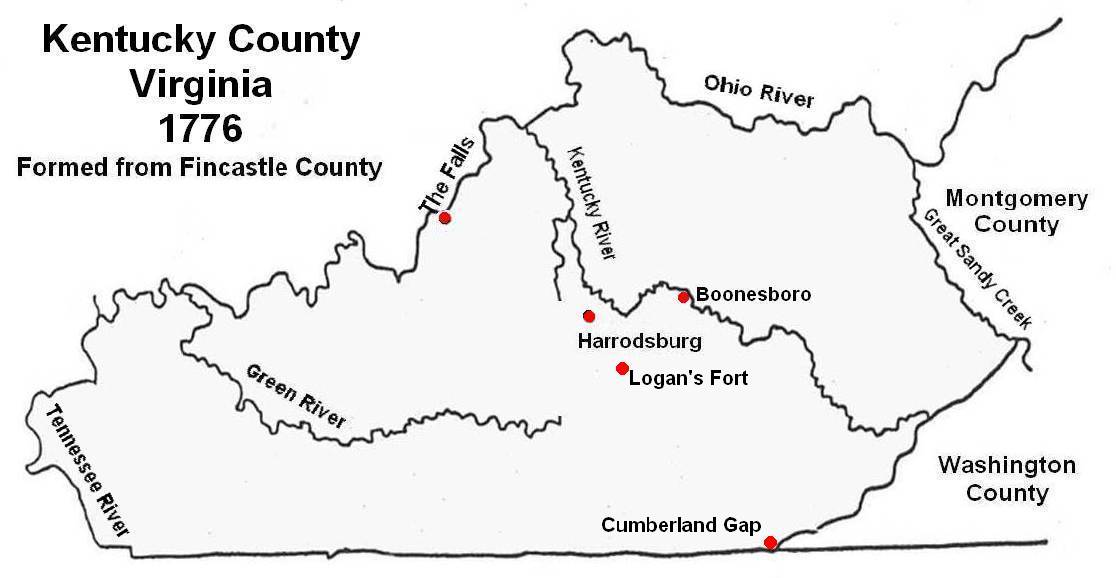
When Kentucky County was formed, it was populated by only a few hundred people in Central Kentucky—far removed from the state capital in Williamsburg. By the end of January 1777, the Indians had driven most of the settlers into forts at Harrodsburg and Boonesborough. By summertime, there were only 121 fighting men in the region. Later in the year, 100 men were recruited from Botetourt and Montgomery counties.
In May 1777, representatives from Kentucky County participated in the Virginia General Assembly when laws were passed regarding the state’s militia and the use of United States bills of credit for trade and in the state. They later passed a long series of Acts to raise taxes and borrow money to fund the war effort. During the following year, Virginia volunteers were assured entitlement to the ‘continental bounty of lands’ that had been established earlier by the Continental Congress. In December 1778, the Southern theater of the war began when the British launched a successful attack on Savannah, Georgia.
1779 Virginia Land Law
During the May 1779 session of the General Assembly, more Acts were passed in support of the war. The most significant Act of the session to affect the settlement of Kentucky became known as the 1779 Land Law:
“An Act for establishing a Land Office and ascertaining the terms and manner of granting waste and unappropriated lands.”
The rush to survey, claim and settle unappropriated land in Kentucky since 1772 had gotten out of control, and this was an attempt by the Assembly to bring some order to the chaos—while also serving the purpose of raising much needed funds for the war. The stated intent of the new law was:
“to encourage the migration of foreigners hither, promote population, increase the annual revenue, and create a fund for discharging the public debt.”
With proof of payment to the treasury, the Land Office could issue a Treasury Warrant, specifying a quantity of land and the rights of its owner —thereafter known as ‘treasury rights.’ The initial rate specified in the law for a warrant was ₤40 per 100 acres. This law later became extremely important regarding its use to purchase unclaimed land in Eastern Kentucky at a very low cost. Seven steps to gain legal title under provisions of the 1779 Land Law can be summarized as:
- A Treasury Warrant is purchased, authorizing the survey of a specified number of acres;
- An entry is recorded in the county where the unappropriated land is to be surveyed;
- A field survey on the land specified in the entry is made by a deputy surveyor;
- The County Surveyor examines and approves the survey;
- The owner of the warrant files the survey at the Virginia Land Office;
- The governor signs a document issuing the grant—also called a patent;
- Title is conveyed and recorded.
Depreciated Money Buys Warrants
During the next session of the Assembly in October 1779, more Acts were passed that directly affected the Western settlements. The most significant one was: “An act to empower the treasurer to receive certain certificates.”
The first article of the Act acknowledges that many inhabitants of Virginia had certificates (bills of credit) which were taken out of circulation by a resolution of Congress, instead of maturing with payment due from the United States. These citizens are entitled to the pre-emption of unappropriated lands, which they cannot do unless such certificates are received in payment at the treasury. Therefore, the State Treasurer was directed to accept these certificates in payment for treasury warrants. The second article directed the State Treasurer to also accept Virginia loan office certificates, with accrued interest, as payment for treasury warrants for any waste or unappropriated lands within the commonwealth.
Paper money throughout the country had depreciated significantly during the previous two years, resulting in it being exchanged in trade—or for specie (coins)—at a fraction of its face value. This Act provided a lucrative option for knowledgeable speculators to acquire this practically worthless money at its bargain rate and use it to buy warrants for large tracts of land.
In November 1781, the Virginia Legislature again acknowledged the rapid decline in the value of paper money and passed an act establishing a scale of depreciation compared to the value of silver and gold. Its preamble begins:
“WHEREAS the paper currency of this state hath, from various causes, greatly depreciated in its value, insomuch that it is neither a proper medium of circulation nor a just standard whereby to settle and adjust debts and contracts…”
The scale of depreciation applied to all debts and contracts entered into or made in current money of Virginia or the United States at the end of 1781 was 1000:1.
Even though paper money had depreciated in value, Continental and Virginia notes could be used to purchase Virginia Treasury Warrants at a fixed rate, as authorized by Virginia laws passed in October 1779 and May 1780. This provided a great financial incentive for speculators to exchange their bills of credit to purchase warrants for unappropriated land, including tens of thousands of acres in the mountains of Eastern Kentucky.
Fayette County (1780-1786)
On November 1, 1780, Kentucky County was divided into three counties: Jefferson, Fayette, and Lincoln. The Big Sandy Valley was a long distance from the county seat in Lexington.
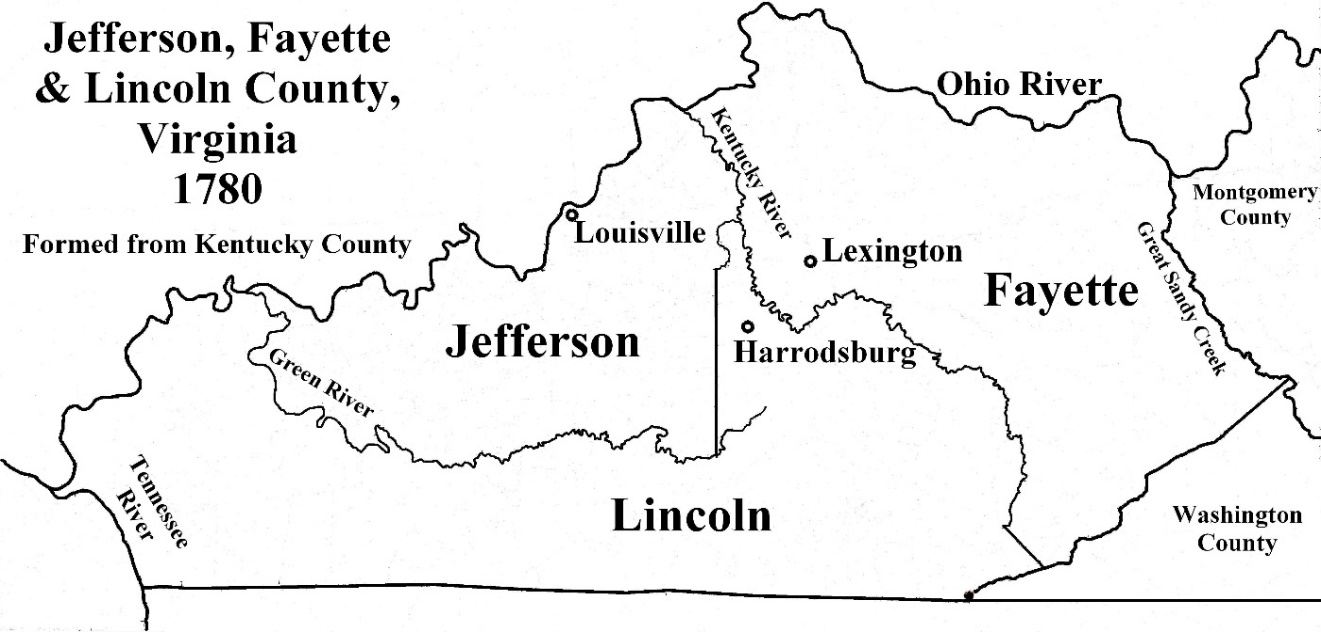
Thomas Marshall was appointed Fayette County Surveyor and served in that office until 1789.
Beginning in November 1782 and continuing through April 1786, approximately 389 entries were made in Fayette County for land in the Big Sandy Valley, 24 extended a few miles down the Ohio River, and 49 were in the Little Sandy Valley. Some entries were simply amendments, more than a hundred were withdrawn, and at least twelve were surveyed but never patented. The first survey on these entries was run in April 1784, the first patent on them was issued in January 1786, and the last patent was issued in November 1811. Maps of tracts that were subsequently surveyed and patented are grouped together according to the time they were surveyed.
Many of the men who came to Col. Marshall’s land office in 1782 to make entries up these valleys owned land in Central Kentucky and knew about the routes through the mountains. Among them was William Russell who first sought to own land in Kentucky in July 1774, when he had Fincastle deputy surveyor John Floyd locate 2,000 acres for him on North Elkhorn Creek near present-day Lexington.
During 1783, 89 entries were made for land in the Big Sandy Valley, but only 55 of them were ever surveyed. About 27 entries were also made in the Little Sandy Valley, and over half of them were surveyed. The first ten Big Sandy entries are dated January 2, 1783, for William Russell, William Lewis and Israel Christian along the Levisa Fork from present-day Paintsville to Prestonsburg. Only two of the ten—both for 1,000 acres for William Lewis—were ever surveyed. His entries were:
“on the first big creek emptying into the Sandy on the Southwest side of Sandy above the mouth of Paint Lick Creek.”
One entry is at the mouth of the creek and the other one continues up the creek, each typically taking in land fit for cultivation for quantity. In October 1797 a survey for 493 acres was run on part of one of the entries for Lewis at the mouth of Abbott Creek—located directly across the Big Sandy from the May 1797 plat of the town of Prestonsburg.
In 1784, 104,587 acres were surveyed in the lower region of the Big Sandy Valley and the Little Sandy Valley. These were the first such surveys run in Eastern Kentucky by virtue of land entries under the 1779 Land Law. In 1785, surveys for 314,700 acres were run up Levisa Fork of Big Sandy and up Beaver Creek in present-day Floyd County and above the mouth of Wolf Creek on the Tug Fork. Additional surveys were run in the region in 1785 and 1786, bringing the total in Fayette County to 144 surveys for 790,437 acres.
On January 12, 1784, the largest single entry for land in Eastern Kentucky (162,518 acres / 255.5 sq. miles) was made in Fayette County by Merry Walker. The entry on Russell Fork of Levisa extends from a point above the mouth of Shelby Creek and goes across the present Kentucky-Virginia border. Subsequent surveys in that region refer to boundaries of Walker’s entry.
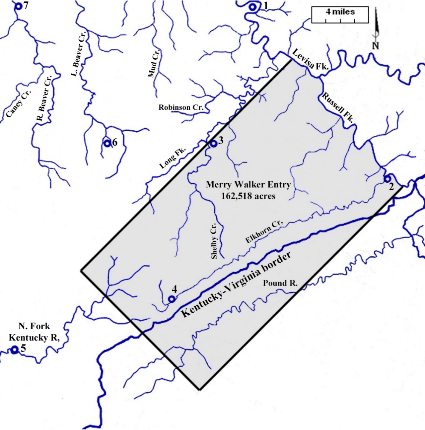 ◄Merry Walker’s January 1784 Fayette County entry on Russell Fork►
Towns established years later in the area:
1. Pikeville 2. Elkhorn City 3. Virgie 4. Jenkins
5. Whitesburg 6. Wheelwright 7. Garrett
Bourbon County (1786-1789)
On May 1, 1786, Bourbon County was formed from Fayette with its county seat in Paris. James Garrard was appointed County Surveyor and he began to send surveyors into Eastern Kentucky in January 1787. He had crews working in the region as late as April 30, 1789, one day before it officially became part of Mason County. Prior to 1787, the southernmost surveys recorded up the Big Sandy Valley were on Beaver Creek. The farthest any survey had been run up the Levisa Fork was within two miles northeast of present-day Paintsville.
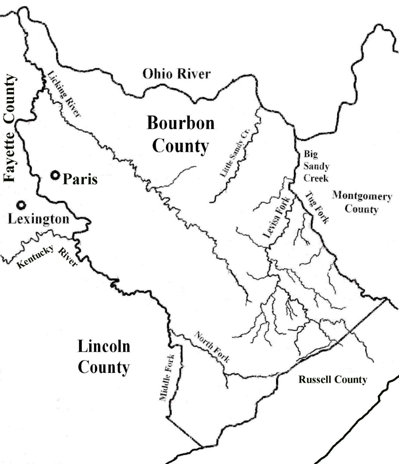
◄Boundary of Bourbon County when it was formed from Fayette County in 1786►
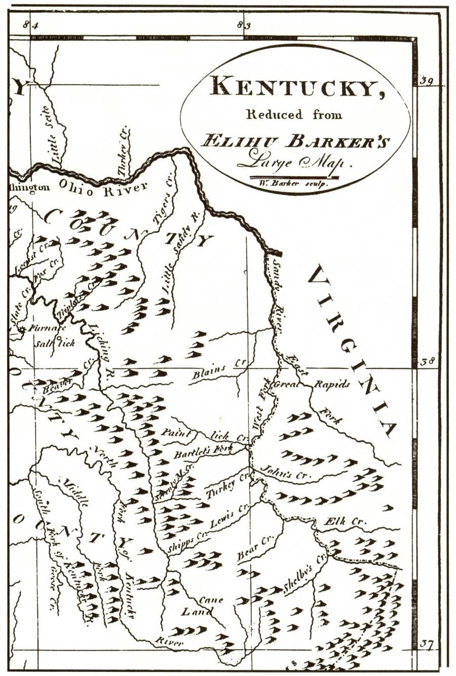
During the first week of 1787, George Lewis surveyed 37,000 acres on the Big Sandy below the mouth of Blaine Creek. During the next few years, Lewis ran 114 surveys in Eastern Kentucky covering about 800,000 acres (1,250 sq. miles).
In mid-April 1787 Lewis took a crew including Nicholas Tomlinson, John Curtis, and Richard Taylor to Russell Fork in the upper reaches of the valley where they ran nineteen surveys covering 204,101 acres (319 sq. miles) during a period of three weeks. These surveys by Lewis are the earliest ones recorded in this easternmost region of Kentucky, and the grantees are the first legal owners of land in the area. Boundaries enclosing the surveys refer to Merry Walker’s 1784 entry. Patents (Grants) issued for land when the region was in Virginia—before 1792—are named by Kentucky Land Office as VA-####. Those patented later in Kentucky are named OK-####.
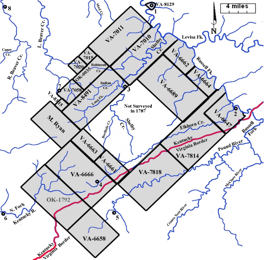
◄Surveys by George Lewis in April, May, and December 1787►
Sites of present-day towns:
1. Pikeville 2. Elkhorn City 3. Virgie 4. Jenkins
5. Pound, VA 6. Whitesburg 7. Wheelwright 8. Garrett
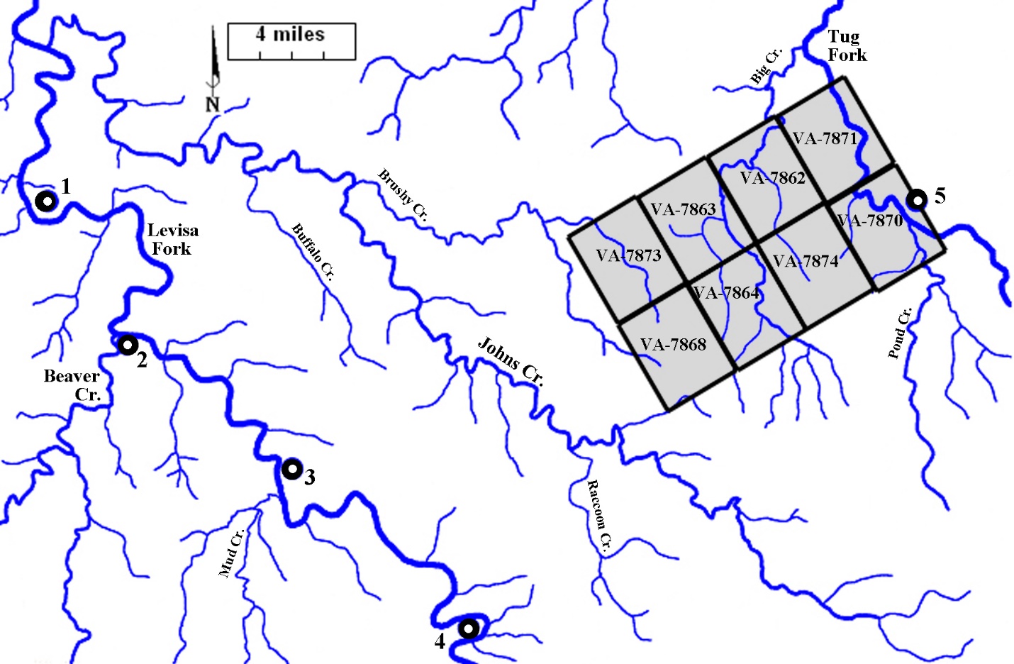
In March 1788, George Lewis returned to Russell Fork above the mouth of Shelby Creek. During the following two months he ran thirteen surveys (totaling over 200,000 acres) along the Big Sandy as far down the river as present-day Paintsville. Men listed in his crew as chain carriers and markers were Nicholas Tomlinson, John Curtis, Jacob Stucker, Israel Tully, William Jones, and Richard Bartlett. Three of the surveys adjoined those Lewis ran in 1787.
◄Two 30,000-acre surveys by George Lewis for John Smith and a
40,418-acre survey for John May and David Ross run in the spring of 1788►
Sites of present-day towns:
1. Pikeville 2. Shelbiana 3. Elkhorn City 4. Virgie 5. Jenkins
Surveys by George Lewis in 1787 have dotted backgrounds.
John Smith—nephew of William Preston and first cousin to John Preston, who had Prestonsburg lots platted in 1797—was also surveying in present-day Pike County in 1788, where he ran eight 5,000-acre surveys for himself extending from Johns Creek to Tug Fork.
 ◄40,000 acres surveyed by John Smith►
Sites of present-day towns:
1. Prestonsburg 2. Allen 3. Betsy Layne 4. Pikeville 5. Williamson, WV
In September 1788, Bourbon County Surveyor James Garrard sent George Lewis to survey a 23,500-acre tract for him along Levisa Fork— above the mouth of Mud Creek near the boundary between present-day Floyd and Pike counties. Members of Lewis’ crew were Nicholas Tomlinson, William Jones and John Curtis who had worked with him on Paint Creek earlier in the spring. When placed on a map this survey slightly overlaps an earlier survey southwest of Pikeville. The overlap is an example of a cumulative error caused by placing surveys run over mountainous terrain—sometimes referred to as ‘slope chaining’—on a modern map, combined with the use of different starting points, such as the mouth of creeks.
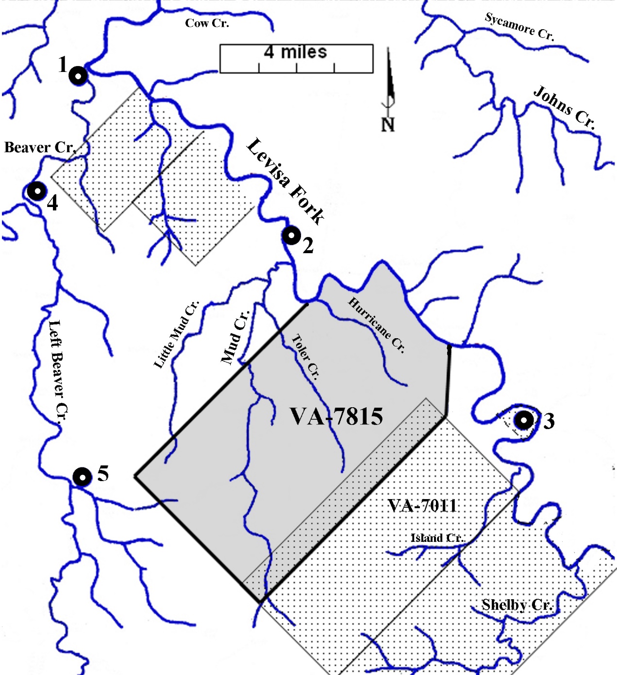
◄Survey by George Lewis for James Garrard
between present-day Betsy Layne and Pikeville►
Previous surveys along the river have dotted backgrounds.
Sites of present-day towns:
1. Allen 2. Betsy Layne 3. Pikeville 4. Martin 5. McDowell
During the spring of 1789, Bourbon County crews were sent to survey entries for land scattered up from the Ohio River to the headwaters of Pound River in present-day Virginia. George Lewis thirteen of surveys that adjoined others he had surveyed in the upper Big Sandy Valley in 1787.
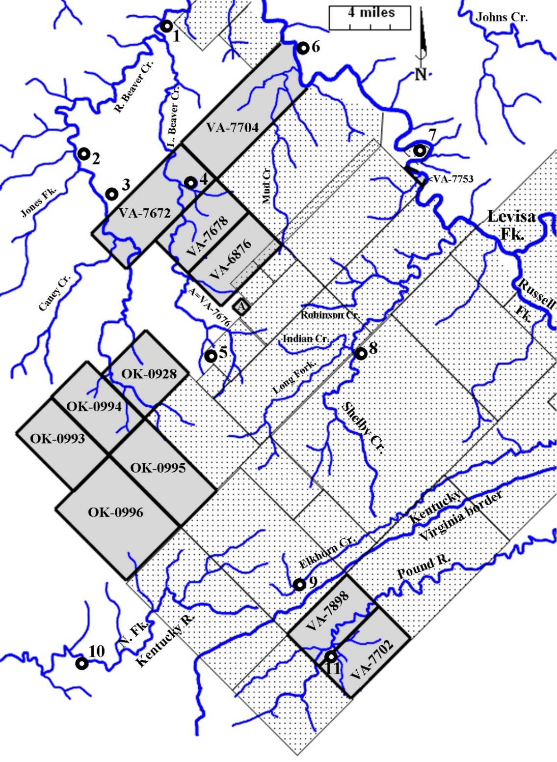
◄Thirteen surveys run by George Lewis in April 1789►
Earlier surveys have dotted backgrounds.
Sites of present-day towns:
1. Martin 2. Garrett 3. Wayland 4. McDowell 5. Wheelwright 6. Betsy Layne
7. Pikeville 8. Virgie 9. Jenkins 10. Whitesburg 11. Pound, Virginia
Mason County (1789-1798)
Mason County was formed from Bourbon County effective May 1, 1789. Washington was named as its county seat and Henry Lee was appointed as Surveyor. Earlier in the year, Charles Vancouver led the first effort to bring settlers to the Big Sandy Valley on land he had patented in December 1788 at the main forks of the river—at present-day Louisa. They deadened trees on several acres of ground and built three cabins and some log pens. By early 1790, the nearest fort in the area (Harman’s Station) was built farther up the Levisa Fork at the mouth of Johns Creek—where Jenny Wiley was rescued. Vancouver’s settlement was abandoned in April 1790 when they could not raise crops following raids by Indians that stole their horses. About the same time, the first cabin was built near the mouth of Sycamore Creek on Johns Creek at the Leslie Settlement.
◄Boundary of Mason County when it was formed from Bourbon County in 1789►
◄Big Sandy Valley: East section of the 1792 map by Elihu Barker►
Sandy River (Big Sandy River)—East Fork (Tug Fork) —West Fork (Levisa Fork)
Blains Cr. (Blaine Cr.) —Paint Lick Cr. (Paint Cr.) —Bartlet’s Fork (Jenny’s Cr.)
Turkey Cr. (Little Paint Cr.) —John’s Cr. (Johns Cr.) —Lewis Creek (Beaver Cr.)
Bear Cr. (Mud Cr.) —Elk Cr. (Stonecoal Cr.) —Shelby’s Cr. (Shelby Cr.)
Will Barker added Cane Run (Middle Cr.) and Raccoon Run (Abbott Cr.)
to his version of the map in 1795.
General Anthony Wayne’s victory at Fallen Timbers near Lake Erie in August 1794 and the signing of the Treaty of Greeneville in August 1795, freed the Ohio Valley from the threat of Indian raids. With the safety of families finally assured, the settlers began to move into the Big Sandy Valley. During the next few years about 75 families came into the valley, strung out in a thin line of cabins from present-day Pikeville to Blockhouse Bottom at the mouth of Johns Creek. However, as evident from records of surveys and patents made earlier, these settlers did not have legal rights to the land where they established their homesteads.
During the years that Eastern Kentucky was in Mason County (1789-1798), Henry Lee sent 21 deputies to run 112 surveys in the region. Patents were issued on 109 of these tracts of land. Only one of these surveys was run in 1789. Beginning at the end of July 1795, the other surveys were scattered from the Ohio River to the headwaters of the Levisa and Tug Forks. Several of them overlapped onto previous patented tracts.
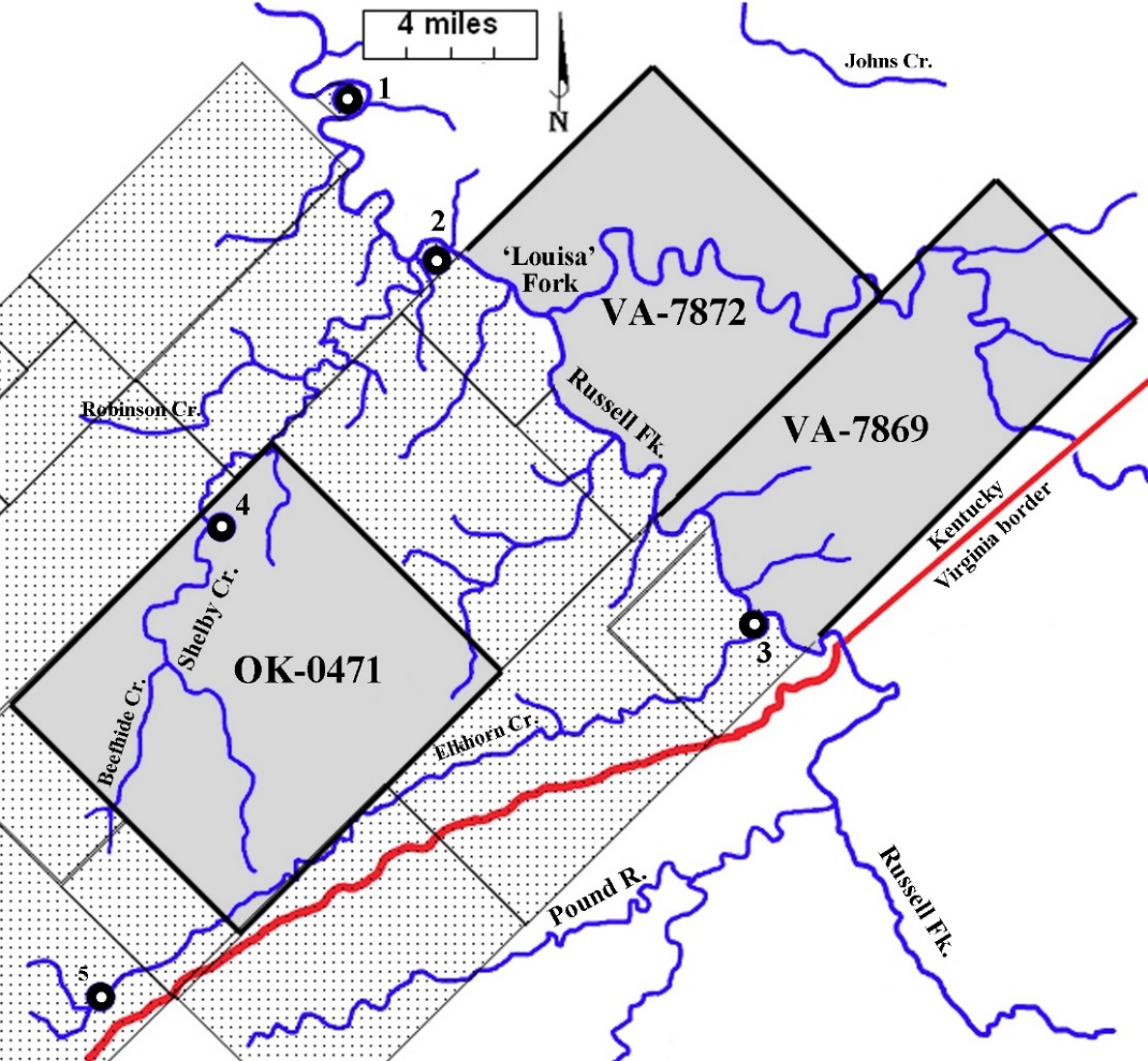
Surveys of interest in present-day Pike County were run in 1796 for Rev. James Madison—fifteen on the Tug Fork in January and thirteen on the Levisa fork in December. Rev. Madison, a cousin of President James Madison, Jr., became president of the College of William and Mary in Williamsburg in 1777, and served in that office until his death in 1812. In 1788, he made entries in Bourbon County for 32,000 acres of land in the Big Sandy Valley. Mason County Surveyor Henry Lee—anxious to please the man who headed the college responsible for qualifying surveyors throughout Virginia—sent John Graham up the valley to run the surveys for Madison. These were the first of many surveys to be run by Graham in the Big Sandy Valley.
These surveys were significantly different from previous ones in the Big Sandy Valley, which typically were large rectangular tracts—often extending across mountains. Entries for the Tug and Levisa tracts allowed the surveyor to run long narrow boundaries that meander along streams—using an exception in the 1779 Land Law that allowed excluding land unfit for cultivation. As a result, the surveys had many calls along their respective boundaries through heavily forested land with corners marked on at least thirty different species of trees. His crew had to be well-equipped for the time it would take to mark the circuitous boundaries of the tracts during one of the coldest months of the year, when snow covered the hilly countryside and streams were often full of ice floes or had a thick sheet of ice from bank to bank. Counter to the practice of surveyors of the period—Graham did not name his markers or chain carriers. These were the only Mason County surveys run in present-day Pike County.
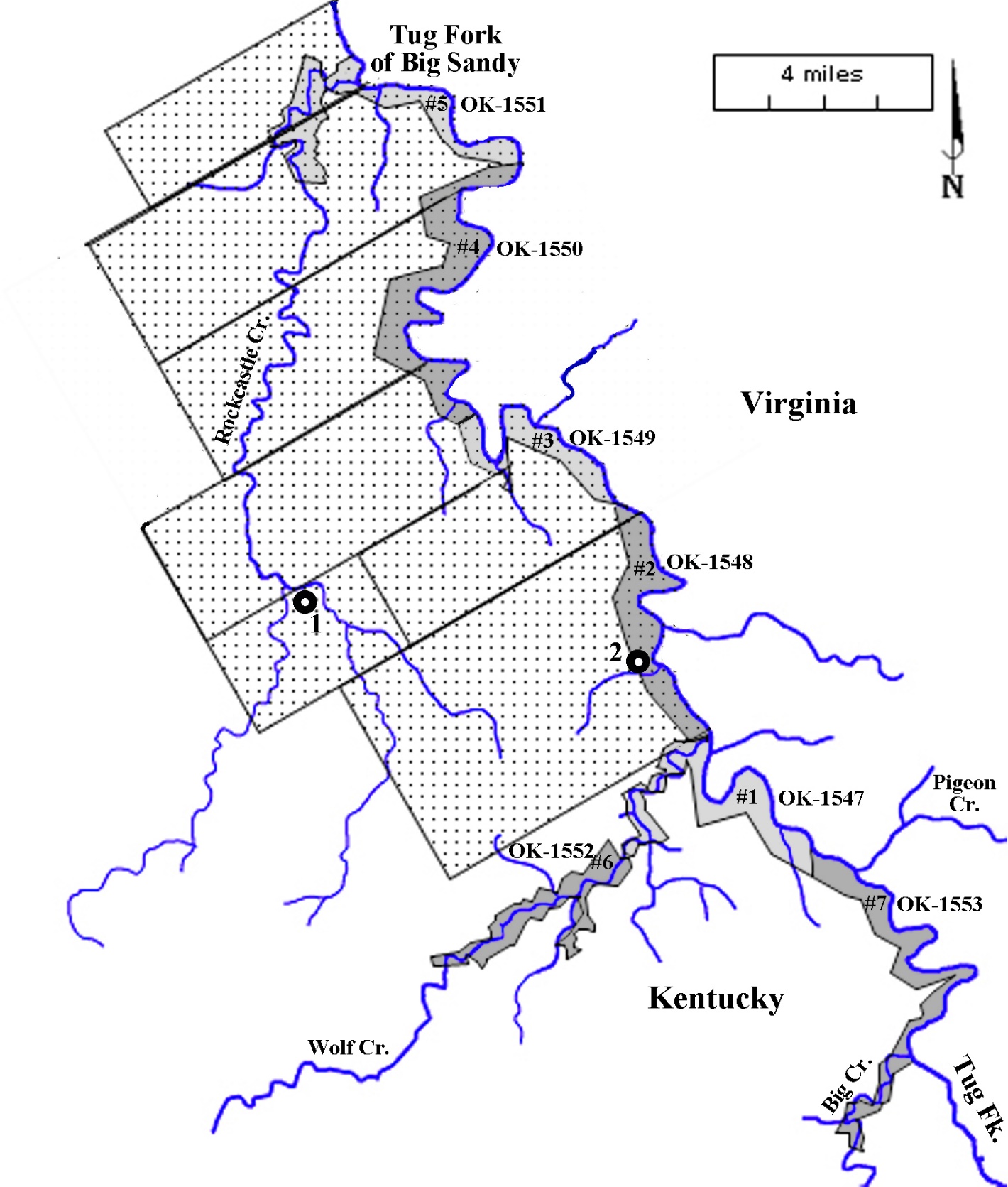
◄Seven January 1796 Tug Fork surveys for Rev. James Madison ►
Previous 1785 surveys have dotted backgrounds.
Sites of present-day towns in Martin County:
1. Inez 2. Warfield
◄Eight more January 1796 Tug Fork surveys for Rev. James Madison►
Previous 1788 surveys have dotted backgrounds.
Sites of present-day towns in West Virginia
1. Williamson 2. Matewan
◄John Graham’s plat of a large bend in the Tug Fork near Matewan►
◄Thirteen December 1796 Levisa Fork surveys for Rev. James Madison►
Previous 1788 and 1789 surveys have dotted backgrounds.
Sites of present-day towns
1. Betsy Layne 2. Pikeville 3. Elkhorn City 4. Virgie 5. Jenkins
On May 3, 1797—a few months after running surveys for Rev. James Madison above and below present-day Pikeville─John Graham surveyed a town plat:
“under the direction of Major Andrew Hood, Mathias Harman and Solomon Stratton, agents for the Adventures on Sandy under Col. John Preston’s Grant.”
The plat assigned the streets and lots of the first town in the valley that would become the county seat of Floyd County in 1800.
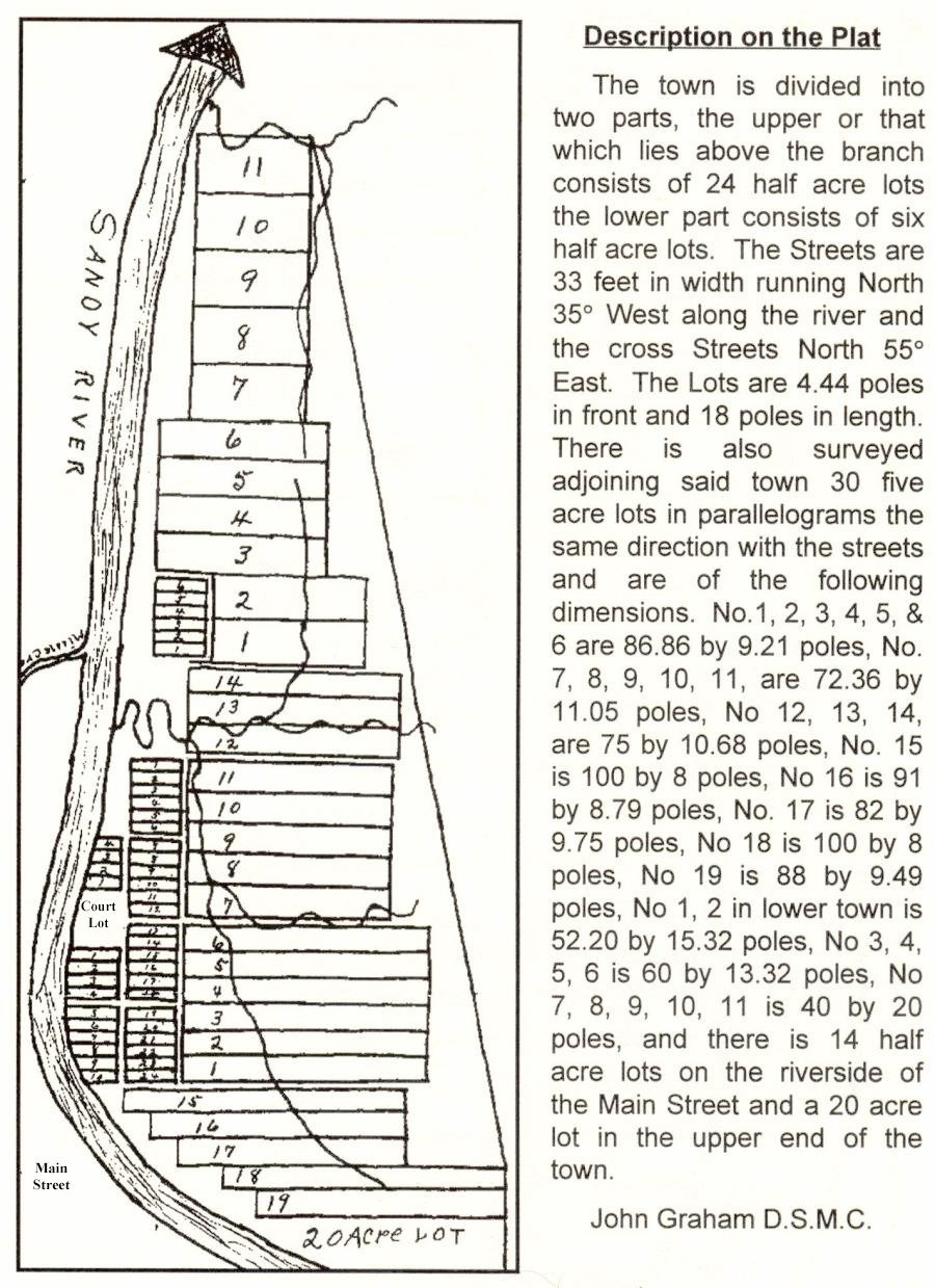
◄John Graham’s 1797 plat of Preston’s Station (Prestonsburg)►
During 1797, no surveys were run in present-day Pike County. However, 29 surveys scattered from the mouth of Big Sandy to Right Beaver Creek were run from May through November.
1796-1798: Law in the Valley
Settlers came to the remote upper Big Sandy Valley in the mid-1790s and were soon in dire need of help for their safety. On June 7, 1796, Governor James Garrard received two petitions requesting appointments for military officers and a Justice of the Peace. One petition—written in first person by Mathias Harman—says he had been selected by citizens of the area to serve as their Captain and represents himself as having been “chosen by Curnal Preston to settle the country and complete his Bisoness.” Harman was referring to John Preston who was busy at the time planning to have land surveyed in the area and to lay out lots for a town. Other militia officers proposed by Harman were Solomon Stratton as Lieutenant, and Thomas Stratton as Sergeant.
The other petition asked the governor to:
“grant to us some form of laws or method so that good men would live at pease and quietness…as we are in a defenceless cuntry exposed to danger both by savages and Bad men.”
Letters written at the end of 1797 by James Young—living in a small settlement at his salt works in present-day David—infer that he was the only Mason County official in the area. He apparently had the support of local settlers to appeal directly to Gov. James Garrard for the appointment of others to assist him. John Campbell went to Frankfort in December 1797 with a letter Young wrote to Garrard on the 12th, asking him to appoint James Paten (Patton) as a Justice of the Peace.
Young wrote Garrard again on January 29, 1798, noting he was thankful for a response. He added:
“we have sum unruly people in this part of the county and it apears that their is a rail needsisity for three Magistrates in this part of the county as we air far from the sait of Government.”
This time James Harris rode to Frankfort with a letter from Young, requesting that Garrard appoint Harris and James Patton as Magistrates and calling them:
“the fitingst men for that purpose as I belive to be rail honest men and of sound judgment.”
Enclosed with the letter were names of forty-one petitioners. Family names familiar in Pike County include Damron, Millard, Haws and Ratliff (spelled three different ways).
Fleming County (1798-1800)
Fleming County was formed from Mason County effective March 1, 1798. The new county—county seat Flemingsburg—extended to the eastern border of Kentucky until Floyd County was formed in June 1800. Governor James Garrard appointed John Spurlock, John Hunt and Michael Cassady as Justices of the Peace and Hugh Fulton as County Surveyor. Spurlock had settled at the site of Preston’s Station before the town plat was surveyed. Hunt and Cassady lived in the Licking Valley. Prior to moving to Kentucky, Fulton had previous experience as a deputy surveyor for William Preston in Montgomery County, Virginia.
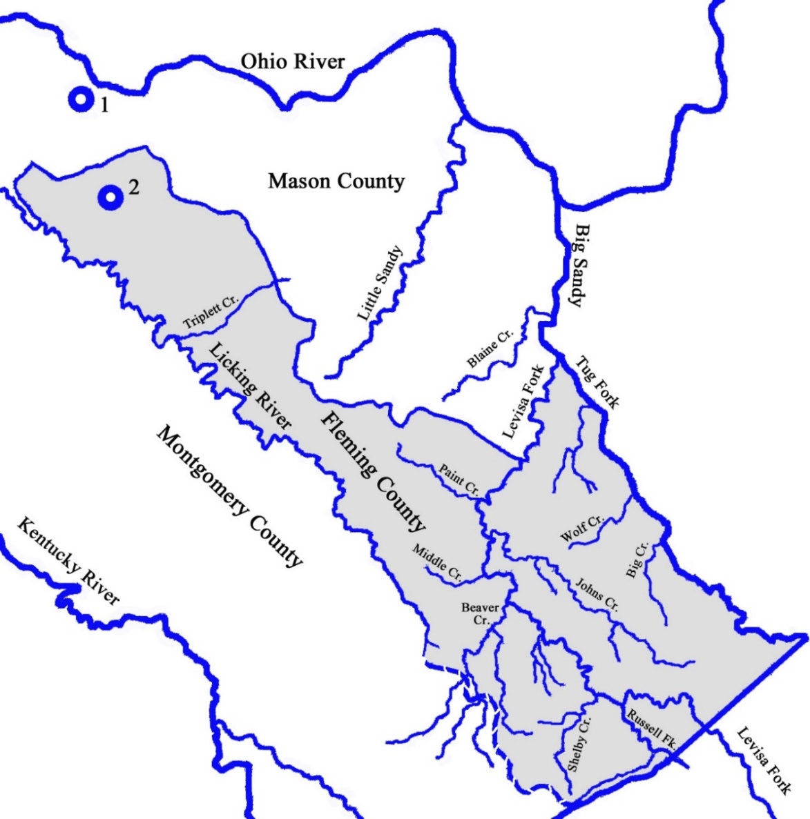
◄Boundary of Fleming County when it was formed from Mason County in 1798►
Montgomery County was formed two years earlier from Clark County.
Sites of County Seats:
1. Washington 2. Flemingsburg
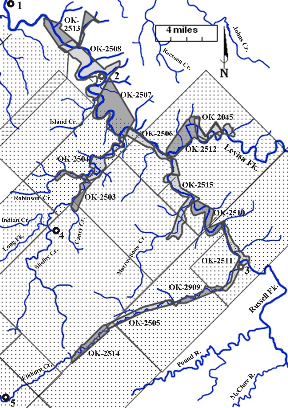
Only a few records exist of any activity by Fleming officials involving people or property in the Big Sandy Valley. Three surveys were run in the waters above the forks of Sandy—land officially in Fleming County—by deputies of Henry Lee, Surveyor of Mason County. Two of them begin at the mouth of Sycamore Creek and extend about twenty miles up Johns Creek.
◄Two 1798 surveys on Johns Creek, beginning at the site of the
Leslie Settlement, across from the mouth of Sycamore Creek►
1. Site of present-day Pikeville
William Robert Lesley (Leslie) built the first cabin in this area about 1790 but didn’t remain there very long. In the fall of 1802, William’s son, Robert, left his home in Virginia with a large family to establish Leslie Settlement—thus they were not living there when these surveys were run.
Floyd County (1800)
In 1799, a few settlers in Eastern Kentucky petitioned the Kentucky General Assembly to create a new county in the region. The formation of Fleming County in 1798 had not brought a county seat far enough east to meet their growing need for local government. On December 13, 1799, the Assembly passed an Act forming Floyd County—named to honor Colonel John Floyd—out of the counties of Fleming, Mason, and Montgomery. The new county (containing more than 3,600 square miles) was officially formed on June 1, 1800, with the county seat in Prestonsburg.
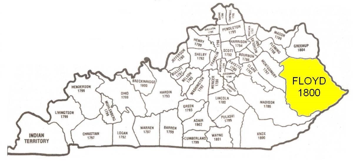
◄ Floyd County contained about 9% of the total area of Kentucky►
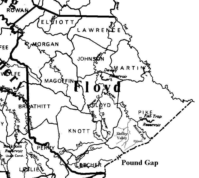
◄1800 boundary of Floyd County showing current county lines►
-
Fincastle notes are sourced from “Virginia’s Western War” by Neal Hammon and Richard Taylor. ↑